Why MeshCore, and what LoRa can and cannot do
What it is
MeshCore is LoRa mesh firmware with three roles: companion radios (user devices that pair with a phone or run standalone), repeaters (fixed routing nodes on high sites), and room servers (store-and-forward shared message boards). Fixed nodes run on small solar and battery systems; the hardware review measured whole-repeater draw of roughly 6–9 mA with power saving on (community measurements; verify).
What it is for
- Short text messages between EOC, dispatch, fire districts, EMS, road crews, and SAR
- Position and status reports; resource requests; welfare-check relay
- Simple telemetry (river gauge, fire lookout, site power status)
Honest limits
- No voice.
- Very low data rate; no large files; capacity drops sharply when many users share the channel.
- Not for time-critical dispatch. Multi-hop contention, hop limits and airtime were not modeled.
- Coverage is terrain-limited: a handheld reaches valley floors and ridge faces with line of sight.
- Assume no criminal justice information (CJI) is carried unless validated by the appropriate authority.
Phased plan
- Assessment
Done in draft: site inventory from FCC and USFS records, hardware review, terrain coverage model. - Architecture / Phase 1: MeshCore
Repeaters on high sites, companion radios for responders, room servers at staffed locations (EOC, Sheriff). - Pilot
Few sites, drive test, one-winter cold-soak and power logging, SOP drafts. - Rollout
Build out the recommended sites, host agreements, training, neighboring-county coordination. - Operations
Test messages, net schedule, drills, spares, documentation. - Lifecycle
Seasonal site checks, battery replacement, firmware review cycle, key backups.
Phase 2: Reticulum (encrypted backbone and gateways)
Reticulum is a separate cryptographic networking stack. It is planned as a later phase for encrypted transport nodes, a county backbone, and gateways between LoRa segments and IP links. MeshCore and Reticulum are not assumed to interoperate natively; any bridging between them would be treated as experimental until documented. Phase 1 is MeshCore only. In the planning scenario, inter-site links must work over RF (LoRa, or point-to-point Wi-Fi or microwave), not over the internet.
Interactive map: the proposed design
The map shows only the proposed 10 sites, the modeled links among them, and the modeled coverage of that design. Click any marker or line. Overlay colors: one site with at least 10 dB margin, two or more sites, marginal (0–10 dB). Link lines: ≥20 dB, 10–20 dB. Dots: backbone site, valley-fill site (Star Peak; Heron home node is hypothetical).
The interactive map needs internet access to load Leaflet and map tiles. The static map below shows the same results.
Basemap tiles: OpenStreetMap or OpenTopoMap (internet required). Overlay and site data are bundled with this page. The Heron home node location is a placeholder point, not a real parcel. The backbone coverage was modeled from the Green Mountain summit (about 1 mile from the USFS site point).
Static map (fallback and print)
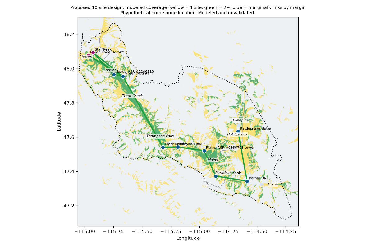
Sites
Site candidates came from public FCC antenna structure (ASR) and license (ULS) records and the USFS communications-site layer: 128 candidate locations (32 registered towers, 8 USFS communication sites in the county, about 88 FCC license clusters; the rest are USFS sites just across the county line). The planning assumption is that permission will be obtained for all public-land sites, and that no commercial power is available, so every site is sized for solar and battery operation.
*Verified location: the location and elevation appear in the USFS communications-site record. Lease availability, power and access are not verified. **Star Peak: coordinates verified (USGS GNIS and OpenStreetMap); land manager, lookout status, lease, power and access are not. "Unverified" sites come from FCC registrations whose status, ownership and mounting rights are unconfirmed. "Power" is the published USFS yes/no field or “unknown”; it is not a field survey.
Proposed backbone (8)
| Site | Elevation (ground) | Owner / record | Power (as published) | Role | Status |
|---|---|---|---|---|---|
| Patricks Knob | 2086 m / 6844 ft (ground) | USFS designated comm site (High Power) | USFS field "power": Yes | Backbone anchor: Plains/Paradise/MT-200 east valley; hub for Perma, Oliver and Plains-ridge links. | Verified location* |
| Clark Mountain (USFS Site 2) | 1545 m / 5069 ft (ground) | USFS designated comm site (High Power) | USFS field "power": Yes | Backbone anchor: Thompson Falls and MT-200 west; links Eddy, State WNKH762, Green Mtn. | Verified location* |
| Eddy Mountain | 2121 m / 6959 ft (ground) | USFS designated comm site (None) | USFS field "power": Unknown | Backbone relay: Thompson Falls/Plains gap; links Clark, State WNKH762, Plains-ridge tower, Minton. | Verified location* |
| Green Mountain (USFS point) | 1440 m / 4724 ft (ground) | USFS designated comm site (Low Power) | USFS field "power": Yes | Backbone anchor (USFS comm site point): Noxon, Trout Creek area; link to Clark and Noxon dam tower. NOTE: Recommended-8 coverage overlays were modeled at the nearby SUMMIT variant (1.7 km away), not at this point. | Verified location* |
| Rattlesnake Butte | 1132 m / 3714 ft (ground) | Hot Springs TV District | unknown | Backbone: Hot Springs and Lonepine; links Oliver Point and Perma BNSF. | Unverified |
| Perma BNSF | 1477 m / 4846 ft (ground) | BNSF Railway Company (+ Industrial Communications & Electronics) | unknown | Backbone: south end (Dixon/Lonepine); links Patricks Knob and Rattlesnake Butte. | Unverified |
| Plains ASR A0866791 tower | 1167 m / 3830 ft (ground) | MMM LICENSE LLC | unknown | Backbone relay (non-Tier-list): closes Eddy-Patricks gap; second Plains/Paradise coverage. Modeled at tower height 15.2 m. | Unverified |
| Noxon ASR A1246210 | 711 m / 2334 ft (ground) | AVISTA CORPORATION | unknown | Backbone: Noxon second coverage; link to Green Mtn USFS point. Modeled at tower height 76.2 m. | Unverified |
Two of the eight are existing towers found in FCC records (Plains ridge ASR A0866791, Noxon ASR A1246210) and need an ownership, status and co-location check. The Plains tower links the western and eastern site groups, because Clark Mountain to Patricks Knob is terrain-blocked and Eddy Mountain to Patricks Knob is marginal.
Valley fill (Heron and Bull River area)
| Site | Elevation (ground) | Owner / record | Power (as published) | Role | Status |
|---|---|---|---|---|---|
| Star Peak | 1874 m / 6148 ft (ground) | n/a (GNIS summit; historic lookout; land manager unverified - likely USFS Kootenai NF) | unknown (assume none; solar/battery) | Valley-fill ridge repeater: Noxon, Trout Creek, MT-200 west of Trout Creek 2-site overlap, ridge links to Berray/Green/Minton/Noxon dam. Does NOT reach Heron town (terrain shadow, -35 dB) - needs a Heron home node. | Partly verified** |
| Home node - Heron (HYPOTHETICAL) | 705 m / 2313 ft (ground) | HYPOTHETICAL - private-land host needed | Not applicable; size solar+battery same as ridge (no-commercial-power assumption); host grid only as backup charger | Valley-fill: fixes Heron town (+21 dB, 96% of 2 km disk) and MT-200 near Heron. Backbone path: Green Mtn (26 km, +26 dB, thin 8 m clearance) and junction node (+19 dB). | Hypothetical |
Links among the proposed sites (worst-direction margin vs. −127 dBm, 6 dBi both ends)
| Link | Margin | Distance | Line of sight |
|---|---|---|---|
| Noxon ASR A1246210 ↔ Green Mountain (USFS point) | +39 dB | 6.1 km | yes (terrain profile, k=4/3) |
| Clark Mountain (USFS Site 2) ↔ Eddy Mountain | +35 dB | 9.8 km | yes (terrain profile, k=4/3) |
| Plains ASR A0866791 tower ↔ Patricks Knob | +30 dB | 18.2 km | yes (terrain profile, k=4/3) |
| Plains ASR A0866791 tower ↔ Eddy Mountain | +30 dB | 17.3 km | yes (terrain profile, k=4/3) |
| Star Peak ↔ Noxon ASR A1246210 | +29 dB | 19.6 km | yes (terrain profile, k=4/3) |
| Patricks Knob ↔ Perma BNSF | +28 dB | 20.8 km | yes (terrain profile, k=4/3) |
| Star Peak ↔ Green Mountain (USFS point) | +27 dB | 24.7 km | yes (terrain profile, k=4/3) |
| Home node - Heron (HYPOTHETICAL) ↔ Green Mountain (USFS point) | +26 dB | 26.2 km | yes (terrain profile, k=4/3) |
| Perma BNSF ↔ Rattlesnake Butte | +24 dB | 32.8 km | yes (terrain profile, k=4/3) |
| Clark Mountain (USFS Site 2) ↔ Green Mountain (USFS point) | +20 dB | 52.9 km | yes (terrain profile, k=4/3) |
Home node links are marginal-clearance: the Heron node to Green Mountain path has only about 8 m of clearance. Link margins to the Green Mountain USFS point are as modeled, but backbone coverage overlays use the nearby summit.
Coverage results (modeled, unvalidated)
County area, communities and highways (≥10 dB margin)
| Site set | Sites | County area, 1+ sites | 2+ sites | Communities, 1+ | 2+ | MT-200/28/135 length, 1+ | 2+ |
|---|---|---|---|---|---|---|---|
| Backbone 8 only | 8 | 30.7% | 10.1% | 8/9 | 4/9 | 66.0% | 27.9% |
| Proposed 10 (8 + Star Peak + Heron home node) | 10 | 34.2% | 12.6% | 9/9 | 5/9 | 68% | 39% |
| Sensitivity of the backbone 8 | County area | Communities | Highway length |
|---|---|---|---|
| Backbone 8 at 0 dB margin | 32.4% | 8/9 | 70.1% |
| Backbone 8 at 20 dB margin (in-vehicle / heavy forest allowance) | 26.1% | 7/9 | 64.1% |
By community: best margin (dB) / number of sites at ≥10 dB
| Community | Backbone 8 only | Proposed 10 |
|---|---|---|
| Thompson Falls | +33 dB / 2 | +33 dB / 2 |
| Plains | +31 dB / 2 | +31 dB / 2 |
| Hot Springs | +42 dB / 1 | +42 dB / 1 |
| Trout Creek | +27 dB / 2 | +27 dB / 3 |
| Noxon | +20 dB / 1 | +25 dB / 2 |
| Heron | -4 dB / 0 | +21 dB / 1 |
| Dixon | +25 dB / 1 | +25 dB / 1 |
| Paradise | +24 dB / 1 | +24 dB / 1 |
| Lonepine | +18 dB / 2 | +18 dB / 2 |
Margin is predicted received power minus −127 dBm for a 0 dBi handheld. A community is counted covered at ≥10 dB. The 8 backbone sites reach 8 of 9 communities; Heron is at −4 dB until Star Peak and the Heron node are added. In the proposed 10-site design, Hot Springs, Dixon and Paradise are still each reached by a single site.
By highway (≥10 dB, % of length in county)
| Highway | Length sampled | Backbone 8, 1+ sites | Backbone 8, 2+ sites |
|---|---|---|---|
| MT-135 | 21 km | 1.2% | 0.0% |
| MT-200 | 186 km | 75.6% | 36.8% |
| MT-28 | 46 km | 56.8% | 4.4% |
MT-135 is essentially uncovered by any modeled design (about 1%). MT-28 is about 57% covered but only about 4% by two sites. MT-200 west of Trout Creek is improved by the valley-fill sites (94% covered, 71% by two sites, in the 10-site design).
Effect of the valley-fill additions (Heron, Bull River MT-56)
| Option | Sites | Heron margin / sites | MT-56 length 1+ / 2+ | MT-200 west of Trout Creek 1+ / 2+ | Noxon sites | County area 1+ / 2+ | Communities 1+ / 2+ |
|---|---|---|---|---|---|---|---|
| Backbone 8 only (baseline) | 8 | -4 dB / 0 | 5% / 5% | 83% / 32% | 1 | 30.7% / 10.1% | 8/9 / 4/9 |
| + Star Peak | 9 | -4 dB / 0 | 16% / 5% | 83% / 63% | 2 | 33.7% / 12.0% | 8/9 / 5/9 |
| + Star Peak + Heron home node only (the proposed 10 sites) | 10 | +21 dB / 1 | 16% / 5% | 94% / 71% | 2 | 34.2% / 12.6% | 9/9 / 5/9 |
Bull River valley (MT-56) stays weak: it is narrow, winding and forested, and the proposed design covers only about 16% of its length. Additional valley nodes were modeled but are not part of this proposal; improving MT-56 would need several more valley nodes, or companion-to-companion relaying.
Model assumptions
- Engine: the Meshtastic Site Planner's SPLAT!/ITM (Longley-Rice) coverage engine, run natively, with 1-arcsec SRTM terrain downsampled to about 90 m. Used here as a generic LoRa propagation model; MeshCore is not modeled specifically.
- Radio: 910.525 MHz, SF7 / BW 62.5 kHz / CR5 (MeshCore "USA/Canada" preset; verify before deployment). Receiver sensitivity about −127 dBm, derived from the SX1262 datasheet (verify).
- Repeater: 22 dBm transmit, 1 dB feedline, 6 dBi omni antenna, 6 m mast (home nodes 8 m). Handheld: 1.5 m, 0 dBi.
- Statistics: 95% confidence / 95% reliability; 1 m clutter. “Covered” means ≥10 dB margin as a rough allowance for foliage and body loss.
- Data: TIGER 2023 places, roads and county outline (county area 7,220 km², including the Flathead Reservation portion); highways sampled about every 250 m.
Limitations
- Not drive-tested. Predictions are unverified until validated in the field.
- A 90 m surface model misses small ridges and canopy; no foliage, vehicle, body or building loss is modeled beyond the 10 dB allowance. Handhelds in valley bottoms or vehicles may see 10–20 dB worse.
- Multi-hop contention, hop limits and airtime are not modeled.
- Tower-top heights on FCC-registered towers assume mounting at the registered height and need owner agreement; registration status can be stale.
- Results at the Green Mountain summit and home node points depend on locations that are not confirmed sites.
Cheap ways to improve real-world coverage
- Fill nodes at fire stations, schools and town halls (small solar kits).
- Roof-mount vehicle antennas for responders; typically gains 10 dB or more compared with a handheld.
- Drive test with borrowed radios before buying at scale.
Hardware standard builds and power sizing
Prices and specifications come from a Nov 2026 web review (MeshCore firmware release v1.18.0, Oct 15, 2026). Prices move often: re-quote before budgeting.
| Role | Standard pick | Rough price | Notes |
|---|---|---|---|
| Ridge / fixed repeater | nRF52840 + SX1262 board: RAK4631 (WisBlock) or RAK WisMesh Repeater; SenseCAP Solar Node P1-Pro as a turnkey alternate for low-priority valley sites | $19.50–25.70 starter kit; $99–299 WisMesh Repeater; P1-Pro $100.99 | Officially supported repeater firmware. Board operating temperature for RAK4631 not found: verify. ESP32 boards draw more; use only where Wi-Fi is needed. |
| Field companion | SenseCAP T1000-E with the MeshCore phone app | $42.99–57.85 | Small, rugged (verify IP rating); needs a phone. |
| Command post / vehicle | LilyGO T-Deck Plus (standalone screen and keyboard) | $61.34 and up | Works without a phone; shorter battery life; less rugged. |
| Room server | nRF52 board (RAK4631 or T114) at a staffed, powered location (EOC, Sheriff's office) on UPS plus solar backup | Similar to a repeater | Keep ridge sites repeater-only. Room capacity and retention limits unverified. |
| Antenna / protection | 6 dBi 902–928 MHz fiberglass omni, short jumper, N-type lightning arrestor | Antenna $15–350; arrestor $19.95–149.99 | Short feedline: a few feet beats 100 ft of cable (LMR-400 about 3.9 dB per 100 ft at 900 MHz). |
Solar, battery and cold-weather sizing (first cut, per fixed site; superseded by the per-site Power & solar section)
Load
Design load 25 mA @ 3.7 V ≈ 2.2 Wh/day, rounded to 3 Wh/day at the battery. The optimistic case from official PR measurements (5.8 mA) is about 0.44 Wh/day. Run powersaving on, GPS off, 22 dBm or lower.
Battery
14 days autonomy (assumption) needs about 75 Wh after depth-of-discharge and cold derating. Pick: 12 V 12 Ah LiFePO4 (about 154 Wh), about 25 days at 3 Wh/day, in an insulated box with low-temperature charge cutoff and temperature logging.
Panel
December sun is only about 0.9 kWh/m²/day on a horizontal surface (NASA POWER regional climatology, not a ridge). Minimum panel about 5 W; pick 20 W at 55–60° tilt, steep to shed snow, with a 75/10-class MPPT controller and battery temperature sensor.
Power & solar: per-site sizing (off-grid, severe winter)
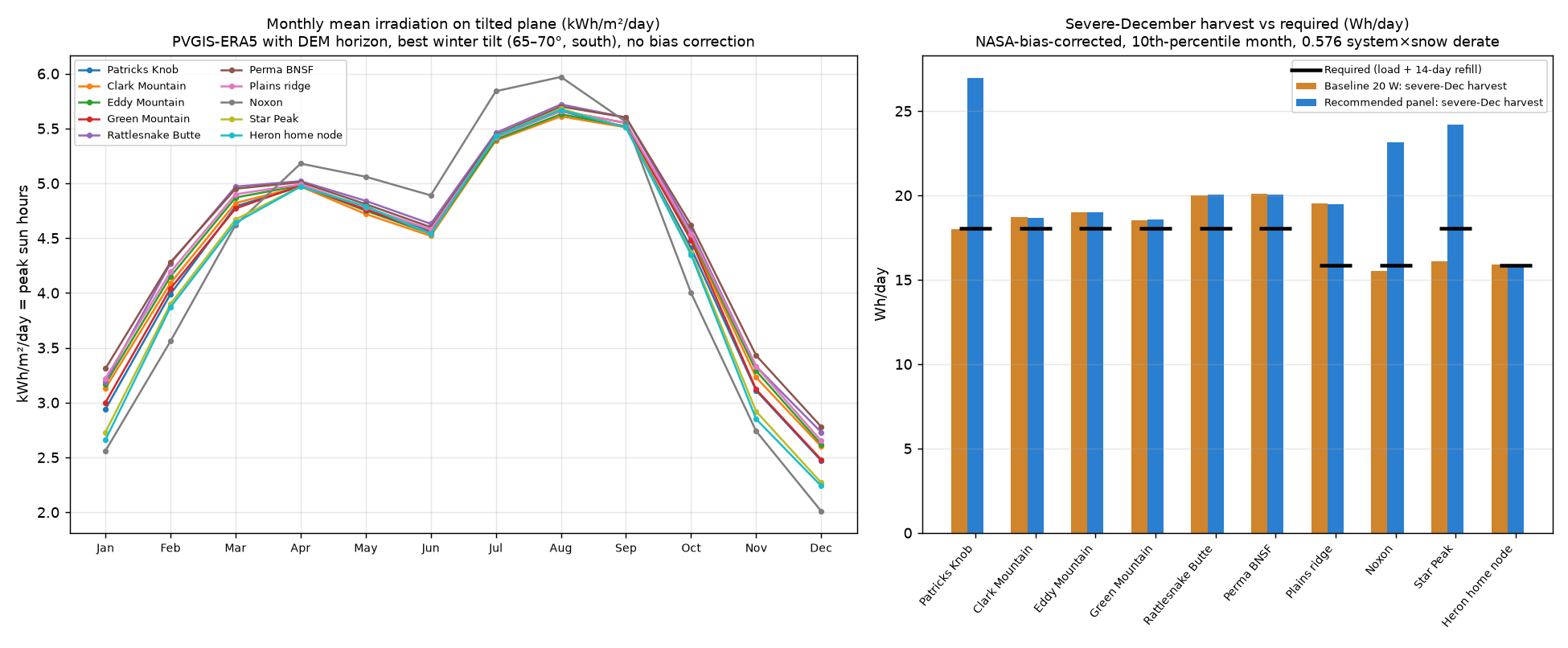
Answer: the baseline kit (12 V 12 Ah LiFePO4 + 20 W panel) is close but not enough everywhere for a severe winter with a busy mesh. A 20 W panel is adequate at most sites, but Patricks Knob, Noxon dam tower and Star Peak need about 30 W (horizon shading or lower winter sun). The battery is the more common shortfall: 12 Ah gives about 8 days after cold derating, so remote summits should step up to 20 Ah for 10 days. The charge controller's own drain is more than half the load, so choose a low-quiescent controller. Cold charging protection matters more than capacity. Procurement note: no 12 Ah LiFePO4 with cold-charge protection was found, so the budget uses a 20 Ah battery at every site, including the sites sized at 12 Ah.
| Site | Elev. (m) | Tilt | Dec PSH mean / severe* | Design Wh/day | Panel | Battery (12.8 V) | Autonomy d, target (actual) | Design low** | Baseline 12 Ah / 20 W |
|---|---|---|---|---|---|---|---|---|---|
| Patricks Knob Horizon shading cuts Dec sun 9.5% (south-sector terrain up to 13.4°) | 2086 | 70° | 2.47 / 1.56 | 10.56 | 30 W | 20 Ah | 10 (13.6) | -36°C | FAIL (battery, panel short) 20 W: 18.0 Wh/d; 12 Ah: 8.1 d |
| Clark Mountain | 1545 | 70° | 2.6 / 1.62 | 10.56 | 20 W | 20 Ah | 10 (13.6) | -33°C | FAIL (battery short) 20 W: 18.7 Wh/d; 12 Ah: 8.1 d |
| Eddy Mountain | 2121 | 70° | 2.62 / 1.65 | 10.56 | 20 W | 20 Ah | 10 (13.6) | -36°C | FAIL (battery short) 20 W: 19.0 Wh/d; 12 Ah: 8.1 d |
| Green Mountain (summit) | 1650 | 70° | 2.48 / 1.61 | 10.56 | 20 W | 20 Ah | 10 (13.6) | -35°C | FAIL (battery short) 20 W: 18.5 Wh/d; 12 Ah: 8.1 d |
| Rattlesnake Butte | 1132 | 70° | 2.73 / 1.74 | 10.56 | 20 W | 20 Ah | 10 (13.6) | -37°C | FAIL (battery short) 20 W: 20.0 Wh/d; 12 Ah: 8.1 d |
| Perma BNSF | 1477 | 70° | 2.78 / 1.74 | 10.56 | 20 W | 20 Ah | 10 (13.6) | -37°C | FAIL (battery short) 20 W: 20.1 Wh/d; 12 Ah: 8.1 d |
| Plains ridge tower (ASR A0866791) | 1167 | 70° | 2.65 / 1.69 | 10.56 | 20 W | 12 Ah | 7 (8.1) | -36°C | PASS 20 W: 19.5 Wh/d; 12 Ah: 8.1 d |
| Noxon Rapids dam tower (ASR A1246210) Horizon shading cuts Dec sun 18.6% (south-sector terrain up to 22.9°) | 711 | 65° | 2.01 / 1.34 | 10.56 | 30 W | 12 Ah | 7 (8.1) | -35°C | FAIL (panel short) 20 W: 15.5 Wh/d; 12 Ah: 8.1 d |
| Star Peak | 1874 | 70° | 2.27 / 1.4 | 10.56 | 30 W | 20 Ah | 10 (13.6) | -35°C | FAIL (battery, panel short) 20 W: 16.1 Wh/d; 12 Ah: 8.1 d |
| Heron home node (hypothetical) | 705 | 70° | 2.24 / 1.38 | 10.56 | 20 W | 12 Ah | 7 (8.1) | -33°C | PASS 20 W: 15.9 Wh/d; 12 Ah: 8.1 d |
*PSH = peak sun hours = kWh/m²/day on a south-facing plane at the tilt shown, December. “Severe” is the 10th-percentile December (mean minus 1.28 interannual standard deviation) after scaling PVGIS down to NASA POWER horizontal sun (a conservative correction of about 0.78–0.85×). **Coldest value of the 2005–2023 ERA5 hourly record and the NASA POWER monthly minimum at the grid cell; not elevation-corrected, verify. Battery autonomy is at 80% depth of discharge with a cold capacity derate (assumption: 0.70 below −25°C). Baseline PASS needs both 12 Ah to cover the target days and 20 W to cover the load plus a 14-day refill of the battery bank in severe December.
Load budget (per site)
| Case | Node current @3.7 V | Wh/day (incl. controller) | Basis |
|---|---|---|---|
| Nominal | 8.6 mA | 3.9 | 7.5 mA powersaving base (6–9 mA measured, official PRs #1238/#2286 and the IoTThinks fork) + 1% TX at 130 mA; buck 75% (assumption) |
| Busy mesh (design) | 25.6 mA | 5.6 | 20 mA continuous RX (RAK4631 datasheet: LoRa RX 17 mA) + 5% TX at 130 mA (datasheet 125 mA @ 20 dBm; 22 dBm figure is an assumption, verify); buck 85% (assumption) |
| Controller | 10 mA @ 12 V | 2.9 | Assumed self-consumption (5–20 mA range; verify the exact controller datasheet). This is about half of the design load: 5 mA saves 1.4 Wh/day, 20 mA adds 2.9 Wh/day. |
| Cold-charge allowance | — | +5.0 | Assumption added to the design load at every site (design lows are below −20°C) to cover a self-heating battery or heater cycling. Warming a ~1.3 kg pack by 25 K is only about 9 Wh (assumed mass and specific heat), but holding an insulated box above freezing for a day would cost far more than a small panel can provide, so the plan is a low-temperature-charge battery in an insulated box, not continuous heating. |
Method and assumptions
- Sun: PVGIS v5.3 (ERA5) monthly irradiation on a south-facing plane for tilts 45–90° with the DEM-calculated horizon at each point; best December tilt is 65–70°. Worst month is December at every site. The NREL PVWatts API did not respond from the build machine, so PVWatts was not used: cross-check at pvwatts.nrel.gov before purchase.
- Panel: W = design Wh/day ÷ (severe PSH × 0.576), where 0.576 = 0.72 system losses (assumption, 28%) × 0.80 snow/rime/soiling derate (assumption), then times (1 + autonomy days ÷ 14) so the bank refills in two weeks. Rounded up to 10/20/30/50 W panels.
- Battery: Wh = design Wh/day × autonomy days ÷ (0.80 DoD × cold derate), at 12.8 V nominal. Autonomy is 10 days for remote summits and 7 days for the easier-access Plains tower, Noxon dam tower and Heron home node (assumption). Rounded up to 6/12/20/30/50 Ah.
- Cold: LiFePO4 will not charge below 0°C (vendor pages in the hardware report), so every site needs a low-temperature-charge-protected or self-heating pack (e.g. models that charge to −20°C), an insulated box, a controller with a battery temperature sensor and low-temperature cutoff, and one winter of logged temperatures. Cold capacity derates of 0.70/0.80/0.90 are assumptions. Verify against the chosen pack's datasheet.
- Shading: PVGIS horizon is terrain only; it does not include trees, buildings or snow-laden branches. Noxon dam tower loses about 19% of December sun to the canyon horizon (south sector up to 23°). Heron home node is at valley floor; terrain costs only about 1% but trees and buildings at a real house site could cost much more: verify on site.
- Snow and rime: the 0.80 derate is a guess for a 70° panel that sheds snow; weeks of rime or fog at a summit could do worse. This is why the autonomy and refill margins are kept.
Sources: PVGIS API v5.3 (re.jrc.ec.europa.eu/api/v5_3, ERA5, DEM horizon); NASA POWER climatology (power.larc.nasa.gov); RAK4631 datasheet currents via the hardware report; MeshCore PRs #1238, #2286; IoTThinks EasySkyMesh PowerSaving17. Full method: POWER.md. Data: power_sizing.csv.
Budget: repriced from the power sizing (Nov 22, 2026)
Answer: the 10 sites cost about $6,900–$10,945 in parts (about $690–$1,095 per site). With one program spare set and 10–15% contingency, plan for $7,988–$13,184. This replaces the earlier unsourced per-site estimate; the main change is that cold-charge-capable 20 Ah batteries cost about $190–210 each.
| Site | Panel | Battery | Low option | High option |
|---|---|---|---|---|
| Patricks Knob | 30 W | 20 Ah | $694 | $1,097 |
| Clark Mountain | 20 W | 20 Ah | $695 | $1,093 |
| Eddy Mountain | 20 W | 20 Ah | $695 | $1,093 |
| Green Mountain (summit) | 20 W | 20 Ah | $695 | $1,093 |
| Rattlesnake Butte | 20 W | 20 Ah | $695 | $1,093 |
| Perma BNSF | 20 W | 20 Ah | $695 | $1,093 |
| Plains ridge tower (ASR A0866791) | 20 W | 20 Ah | $695 | $1,093 |
| Noxon Rapids dam tower (ASR A1246210) | 30 W | 20 Ah | $694 | $1,097 |
| Star Peak | 30 W | 20 Ah | $694 | $1,097 |
| Heron home node (hypothetical) | 20 W | 20 Ah | $647 | $1,093 |
| Subtotal, 10 sites | $6,900 | $10,945 | ||
| Optional: one program spare set | $398 | $597 | ||
| Optional: contingency (10% low / 15% high of subtotal) | $690 | $1,642 | ||
| Program total with spares and contingency | $7,988 | $13,184 |
Low option: RAK4631 starter kit with a Pololu 5 V buck, Proxicast arrestor, LiTime 20 Ah (cold-charge cut-off, no heater), Altelix enclosure, Victron 75/10, no battery sensor, smaller mast. High option: RAK WisMesh Repeater (IP67, 12 V direct), PolyPhaser arrestor, RELiON RB20-LT self-heating 20 Ah, Hammond enclosure, Victron Smart Battery Sense, heavier mast and rod. Panel (20 W or 30 W) follows the power sizing. Every site uses a 20 Ah battery: no 12 Ah LiFePO4 with cold-charge protection was found (LiTime 12 Ah $59.50 and RELiON RB12 $109.95 lack it), so the 12 Ah sites are upsized. The Heron home node low option leaves out the mast and tilt-bracket mast pipe because it may reuse the homeowner’s mount.
Biggest cost drivers (10-site totals, low – high)
| Line | Low | High |
|---|---|---|
| Battery | $1,900 | $2,100 |
| Grounding | $477 | $1,412 |
| Enclosure | $750 | $1,287 |
| Lightning arrestor | $219 | $1,171 |
| Radio / repeater board | $250 | $990 |
| Mast and mount | $830 | $978 |
| Charge controller | $655 | $700 |
| Fuses and cabling | $500 | $660 |
| Temperature sensor | $0 | $391 |
| Solar panel | $303 | $369 |
| Antenna | $350 | $350 |
| Coax | $359 | $299 |
| Insulation | $240 | $240 |
| Voltage regulator | $70 | $0 |
Batteries are the largest line (about $1,900–$2,100). The high-option spread is driven by the arrestor (Proxicast $21.95 vs PolyPhaser $117.10), the ground rod and the radio (RAK4631 kit $24.99 vs WisMesh $99).
Lines still marked “verify”
- Ground rod: low price is an unsourced estimate ($25); the only price found ($118.56, Crescent Electric) looks high. Summits on bedrock may need a different grounding design.
- Wiring, lugs, heat shrink allowance ($15–30) and blade fuses: not priced.
- RAK10721 firmware: it ships with Meshtastic; MeshCore support must be confirmed before buying.
- Stock and listing checks: Newpowa 20 W direct is out of stock (a third-party listing is used for the low price), Renogy 20 W is unavailable on Amazon, and 30 W panel listings are unconfirmed in stock. Hammond PJ12106 and PolyPhaser prices come from search snippets.
- Proxicast arrestor surge rating; tilt bracket is listed for 50 W panels and a 100 km/h wind rating; worm clamps listed are too small for a 1-7/8 in pole.
- Controller wiring: Victron 75/10 draws 10 mA load-off but 19 mA with the load on, so wire the node straight to the battery through a fuse, as the sizing assumed.
Files: bom.csv (line items with sources), BUDGET.md, power_sizing.csv. Existing tower sites (Plains ridge, Noxon dam, Perma BNSF) may add lease or mounting fees not included. Grants and volunteer hours are expected to offset cost but have not been identified.
Compliance and coordination
This is not legal advice. Verify each item below before purchase or installation.
| Topic | Position in this draft | Verify with |
|---|---|---|
| FCC Part 15 (902–928 MHz ISM) | LoRa is planned under Part 15. 47 CFR 15.247(b)(3) allows 1 W conducted power for digital modulation in this band (read on eCFR). The antenna-gain reduction rules and how a 6 dBi omni, cable loss and a 62.5 kHz LoRa setting fit were not confirmed. Stay at 22 dBm and 6 dBi or lower on certified configurations. High-power boards (Station G2/G3, Ikoka 30/33 dBm, T-Beam 1W) can exceed Part 15 at their high settings and are not recommended. | An FCC-experienced RF engineer or counsel; board vendor FCC certification; eCFR 47 CFR 15.247 |
| Amateur radio (Part 97) | Part 97 restricts encryption and agency business. Do not mix encrypted Reticulum traffic or official agency traffic with amateur spectrum. | Licensed amateur volunteers; counsel |
| State coordination | Coordinate with the state interoperability coordinator and SITSD, including State of Montana radio sites that share these peaks, and PSCN/FirstNet where applicable. | Montana state interoperability coordinator; SITSD |
| USFS sites | Public-land sites need USFS authorization (special-use permit); listing as a communications site does not mean a lease is available. This draft assumes permission will be obtained. Star Peak's historic lookout may require heritage review. | USFS lands and special-uses staff: Lolo NF Plains/Thompson Falls RD (406-826-3821) for Patricks Knob, Clark and Eddy; Kootenai NF Cabinet RD (406-827-3533) for Green Mountain and Star Peak. Numbers are from the USFS record; confirm before calling. |
| Private and FCC-registered towers, home hosts | Ownership, status, mounting rights and landlord consent are unconfirmed. The Heron home node requires a written host agreement. | Tower owners named in the site table (Avista, MMM License LLC, BNSF, Hot Springs TV District); host landowners |
| CJIS | Assume no criminal justice information over this layer unless validated. | Sheriff/911 and state CJIS authority |
Risks and open items
| Risk / open item | Why it matters |
|---|---|
| Model not validated | All coverage is predicted; no drive test yet. Real coverage will be worse in canyons, forest and vehicles. |
| Lease, power and access unverified | Public-land permission is assumed, not obtained. Power fields are only published yes/no values. Winter access to ridge sites is limited and unverified. |
| Battery cold performance | Below every LiFePO4 discharge rating at −30°F. Needs insulation or heating and a logged pilot. |
| Solar in winter | PVWatts per site not yet run; ridge conditions (rime, snow burial) could be worse than regional climatology. |
| FCC Part 15 antenna and certification review | Gain, cable loss and 62.5 kHz certification path unconfirmed. |
| Single points of coverage | Hot Springs, Dixon and Paradise are each reached by one site. MT-135 is essentially uncovered; Bull River valley (MT-56) is weak. |
| Hypothetical and unconfirmed locations | The Heron home node and the Green Mountain summit point used in the model are not real, permitted locations. The Heron node's link to Green Mountain has only 8 m of line-of-sight clearance (fragile). Plains ridge and Noxon towers need owner and status checks. |
| Heritage and security | Star Peak historic lookout; unattended-device security and lightning exposure at all sites. |
| Capacity and airtime | Multi-hop contention, hop limits and room-server retention were not modeled; confirm channel settings with neighboring meshes. |
| Hardware data gaps | RAK4631 operating temperature, P1-Pro low-temperature charging behavior, and several prices are unverified. Some newer boards and announced products were not field-proven. |
Next steps
- Site visits and records checks: confirm lease availability, power, ownership and winter access with the USFS offices, SITSD and tower owners above.
- Drive test: borrow a few radios and drive MT-200, MT-28, MT-135 and MT-56 to validate the model before spending real money.
- Cold-soak pilot: build one or two sites and log battery temperature, voltage and solar input through a winter.
- PVWatts: run NREL PVWatts for each site with tilt and shading assumptions.
- Part 15 review: have an RF engineer or counsel confirm the antenna and power configuration.
- Host agreements: identify a willing host for the Heron node and draft an agreement.
- Funding: identify grants and volunteer labor; re-quote hardware.
- SOPs and training: draft test-message schedules, drills and key-custody procedures; define neighboring-county coordination (Lincoln, Flathead, Lake, Mineral, Idaho).
- Phase 2 planning: evaluate Reticulum transport nodes and gateways separately; treat any MeshCore bridging as experimental.
Downloads
- sanders_meshcore_proposed.kmz — Google Earth: proposed design with coverage overlay, sites and links
- sanders_meshcore_proposed_sites.kml — proposed sites and links only (KML)
- proposed_sites.csv — the 10 proposed sites with details
- proposed_links.csv — links among proposed sites
- proposed_community_coverage.csv
- proposed_highway_coverage.csv
- meshcore_hardware_report.md
- hardware.csv
- bom.csv — sourced per-site bill of materials
- BUDGET.md — budget method and sources
- power_sizing.csv — per-site solar/battery sizing
- POWER.md — power method, assumptions and sources
Data sources: FCC ASR/ULS, USFS EDW communications sites, USGS GNIS, Census TIGER 2023, SRTM, NASA POWER, MeshCore documentation, vendor pages (Nov 2026).